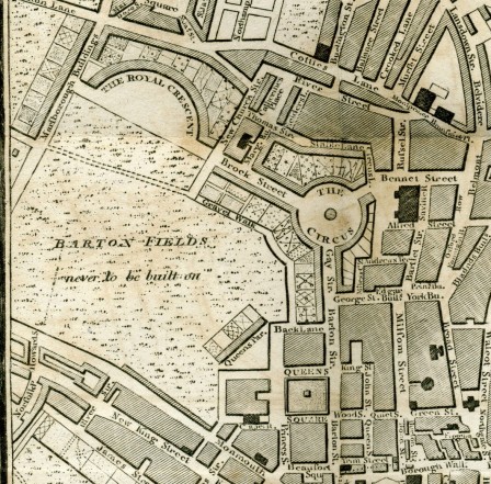
Située à 180 km à l’Ouest de Londres, comptant environ 85.000 habitants, la ville de Bath est classée au Patrimoine Mondial de l’Humanité de l’Unesco. Ville thermale, fondée par les Romains il y a environ 2000 ans, elle s’est considérablement développée au 18ème siècle justement grâce à ses thermes, époque où les membres de la haute société géorgienne se devaient d’aller y prendre les eaux. Le Circus et le Royal Crescent comptent parmi ses réalisations les plus emblématiques.
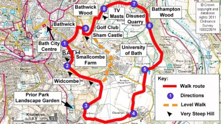
Loger dans une ferme géorgienne détenue (afin de préserver les paysages) par le National Trust puis partir le long des sentiers de la « Bath skyline walk » et traverser le splendide Prior Park Landscape Garden, est certainement l’une des plus agréables façons de découvrir la ville et sa fameuse « skyline ».
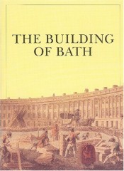
Mais comment celle-ci s’est-elle construite ? Réponses dans le livre « The building of Bath », édité par le Bath Preservation Trust.
Extraits :
Bath is an architectural masterpiece, one of Europe’s most beautiful and elegant cities. We hope to show, however, that Georgian Bath was not just build as a work of art. The search for profit and the moods of fashion mattered as much to people in 18th century as they do to us today. The building of Georgian Bath was a result of one of those moments in history wich are impossible to plan for, moments when individual self interest and the interests of the community, idealism and commerce, architecture and taste, love and money all point in the same direction.
(…)
The vast majority of the new houses built at Bath in the Georgian period were « speculative developments », undertaken in response to the demand for accomodation from the seasonal floods of visitors and the swelling permanent population. The developers and builders were « speculators » because they gambled on finding purchasers for the houses they undertook to construct, and on selling them at a profit.
Whilst in London, John Wood had speculated in building in the booming West End and he was soon looking for a landowner at Bath interested in his schemes. (…) Gray agreed to lease a large plot to John Wood for the latter to build Queen Square upon in return for paying a fixed annual rent of £137 a year, a responsability passed on to his heirs. The lease lasted for 99 years – the most common length of time – and when it expired all the houses on the site were to become the freehold property of Gay’s descendants. Furthermore, once The Square was built more of the family’s land lay ripe for development.
(…)
The next stage was for the develper to « sub-lease » these plots to less wealthy speculators, most of whom were building tradesmen. These signed an agreement to construct a house on the plot within a given period – normally two years – during which time they only paid a token « peppercorn rent ». Few of these small speculators had enough capital to pay for the construction so they borrowed the money from a wealthy private individual or a bank. When the shell of the house was complete the speculator looked for a buyer, often by advertising in the newspapers. If he failed to find one he faced bankruptcy, but in most years of the 18th century the Bath housing market was buoyant enough for him to sell at a price that repaid the loan and rewarded him wis a tidy profit.
The payer paid a lump sum which was for the shell of the house and for the lease on the plot. He also took on the responsability of paying the developer the fixed annual rent and if he sold thhe property on to a new occupier the latter continued to pay it. This is how the developer gained his reward. The rents from the 75 houses in and around Queen Square added up to £305 each year giving Wood, once he had subtracted the £137 rent he owed Gay, a handsome annual profit of £168.
The two Woods left Bath a legacy of over two hundred fine buildings but John Wood the Younger died overburdened by the debts he an dhis father had accumulated, and his widow ended her life in poverty.
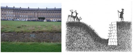
Et au passage, plaisir ludique des jardins anglais, en déambulant devant le Royal Crescent, on en profitera pour admirer le Ha Ha (en pointillé au milieu de Bartons Field sur le plan en haut de ce billet), qui marque en l’occurrence la délimitation entre l’espace privé (« Private lawn. Subscribing residents only » indique le panonceau) et l’espace public. HA HA !! (voir aussi ici).
A lire également nos précédents billets :
– Financiarisation de la ville : le modèle Chicago
– La Skyline de New-York dessinée par les abattements fiscaux
– Barbe Bleue, le foncier et la révolution industrielle
– Il n’est plus de chemin privé si l’histoire un jour y chemine